Oysters are ecological infrastructure. A single adult can filter as much as fifty gallons of water a day; their reefs build habitat for fish and crabs and dampen the wave energy that erodes shorelines. New York Harbor was once one of the most oyster-rich estuaries on Earth. Restoring those reefs is a multi-decade project, and Billion Oyster Project has set a goal of one billion oysters by 2030. Budgets are finite. This framework gives Billion Oyster Project a defensible way to prioritize which of 78 candidate sites and 2,604 acres of urban estuary get restored first.
78
Candidate sitesSpread across five parts of the harbor, ranked by where to start
2,604ac
Total area in playEvery possible site added together
1 billion
Oyster goal by 2030What Billion Oyster Project is working toward in New York Harbor
9
Conditions weighed at each siteSalinity, food, oxygen, depth, waves, and shoreline change, plus three things about what's nearby
How to read the map
Every site is scored on one question: how well the water suits oysters. Salinity, food, oxygen. What it would cost to build a reef there, and what it would take to permit, are questions the score deliberately leaves alone.
Fig. 1 · The 78 sites
All 78 possible sites across New York Harbor. Dot size is the acreage of the site. Dot color is how well the water suits oysters.
Top-ranked sites
Arthur Kill
Rank 1 · Upper Harbor
0.87
Living Breakwaters
Six sites · Ranks 2-7
0.79–0.74
Wolfe's Pond
Rank 8 · Raritan Bay
0.65
Conch Basin
Rank 9 · Jamaica Bay
0.62
Site score
0.200.500.87
Site area
5 ac
100 ac
470 ac
Top-ranked (1-10)
Loading map...
The stakes and the problem
Rebuilding the harbor's oyster reefs, and choosing where to start.
New York Harbor was once one of the most productive estuaries on Earth. Three hundred and fifty square miles of oyster reef, water clear enough to see fifteen feet down, a food web that fed the eastern seaboard. Centuries of dredging, overharvest, and industrial discharge collapsed it. Billion Oyster Project is rebuilding that foundation, with a goal of one billion oysters in the harbor by 2030.
For years, the work moved ahead opportunistically: restoration advanced when a partner provided access or when a specific project received funding. For a young program proving the idea, that was the right call. It gave Billion Oyster Project a decade of data that has shown that, across regions and years, oysters are spawning, and recruitment is occurring harborwide.
A billion oysters is a different kind of problem. Billion Oyster Project now has 78 , and, in order to have a critical mass of oysters reproducing together, it needs ten to fifteen of them funded, permitted, and ready to build by 2029 or 2030. Studying every site halfway just to rule most of them out would burn money the program can't spare. The real question is the whole-harbor one: out of 78, where do you begin?
We've moved from considering each restoration site individually to understanding what the whole system needs to support a self-sustaining population. That's a new way of doing restoration for us.
Carolyn Khoury · Director of Restoration, Billion Oyster Project
Answering that question is the work Billion Oyster Project and Natrx took on together. They did it the harder way, the responsible way. Here is how.
The methodology, made visible
How a framework finds the sites that connect a harbor into a self-sustaining system.
There is an easy way to choose where to build and a right way. The easy way is one formula for the whole harbor, the same numbers everywhere, and a hope that nature plays along. Nature rarely does. Oysters live where the math says they shouldn't, and a healthy harbor changes from one year to the next. So the work went the harder way, the one that leaves room for the people who know these waters and for the fact that nature keeps surprising us. It takes longer. It holds up better.
Over twenty-six weeks, Natrx and Billion Oyster Project built this together. They worked through more than thirty datasets. They sat down with Billion Oyster Project's science team across four working sessions. And they used to build two new layers of data the public record doesn't have.
The work we're doing with Natrx was the first step to providing a science-based framework for us to view all of the sites, and the suitability of those sites, habitat-wise. It's been really exciting to see that product come together.
Cate Collinson · Associate Director of Restoration Projects, Billion Oyster Project
The framework asks two questions, in order. First: where can oysters actually thrive? That comes down to three things about the water, measured at all 78 sites. Second: what does the rest of each place add or take away? How rough the water is, whether the shore is washing away, what the permitting looks like, how well a site fits the mission. The walkthrough below goes in the order the work was done, biology first, then everything around it. Underneath, it asks one plain question: where can the living harbor and the things we build help each other along?
One note on the site score: it compares these 78 places against each other, not against the harbor as a whole. A higher score means a stronger mix of salinity, food, and oxygen for oysters. A 0.90 beats a 0.10. Neither one promises, on its own, that oysters will flourish there. The score's job is to point Billion Oyster Project toward where to look first.
What we have now is a ranking and a confidence layer attached to every site. That's where the science comes in. We're never certain. But knowing where we're confident and where we're not is exactly what we want when we're making these decisions.
Mike McCann · Director of Science and Research, Billion Oyster Project
Loading walkthrough…
What the ranking surfaces
Loading map…
Arthur Kill
Rank 1 · Score 0.87 · Staten Island, Upper Harbor
The strongest site in the whole study sits in the tidal strait between Staten Island and New Jersey, a stretch of water that spent the twentieth century as a byword for pollution. Today it holds the best mix of salinity, food, and oxygen for oysters anywhere among the 78 sites. The water has quietly come back.
The sediment is a work in progress. Arthur Kill falls inside a federal Superfund cleanup area, and any in-water work there has to move through that process. The framework ranks the water. It makes no claim about how easy the permit will be.
Loading map…
Living Breakwaters cluster
Ranks 2–7 · Scores 0.79 to 0.74 · Raritan Bay
Six spots inside the Living Breakwaters system, the SCAPE-designed seawall-and-reef project off Tottenville, take second through seventh place. The water around Living Breakwaters is some of the best in the harbor for adding more reef. The ranking lands on a place the harbor already chose to protect.
Loading map…
Wolfe's Pond
Rank 8 · Score 0.65 · Raritan Bay
Wolfe's Pond Park is public Staten Island parkland, open to anyone. It scores well on every measure of the water, and the building conditions there are workable. A strong site that people can actually visit and watch come back to life.
What the analysis made visible
Three patterns the ranking surfaced.
The ranking did its main job. It told Billion Oyster Project which places give oysters the best shot. Three more things stand out inside it, and they shape what comes next.
The best water is not always the easiest place to build.
The score measures one thing: whether the water at a site suits oysters. Salinity, food, oxygen. That is the question the science can answer cleanly, so that is the question it answers. Everything else a site carries, wave energy, an eroding shore, an outfall pipe, a Superfund boundary, sits in a separate layer, visible but never folded into the number.
Arthur Kill is where that choice carries the most weight. It ranks first in the harbor on water quality, and it sits inside a federal Superfund cleanup area, which makes it among the hardest sites to permit that Billion Oyster Project could choose. A framework built to flatter itself would have quietly weighted that away and produced a tidier list. This one puts both facts on the table and leaves the judgment where it belongs, with the people who have to defend it to a regulator.
That is the difference between a ranking and a decision. The framework delivers the first so Billion Oyster Project can make the second.
Oysters and shorelines, one intervention.
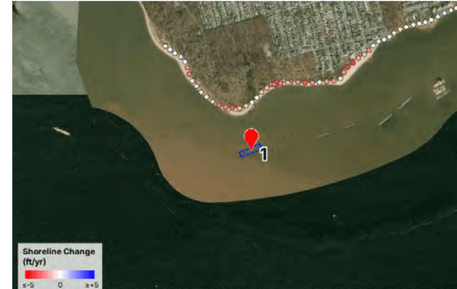
Some of the higher-ranked sites sit next to a shoreline that is washing away. Using aerial imagery going back to 2010, Natrx Assess measured how every site's shoreline has moved. Eight sites are losing more than a foot of land a year. Fifteen more are slipping back more slowly. A few of them rank high for oysters too. And an oyster reef is a natural breakwater: it takes the force out of the waves and slows the land's retreat. So where good water meets a fraying shore, one reef does two jobs at once, a home for oysters and a guard for the coast.
Shoreline change at Living Breakwaters, off Tottenville, Staten Island. Each point measures how far the shore has moved per year. Red is retreat, blue is gain. Source: Natrx Assess, using NAIP aerial imagery and the Marsh Edge from Image Processing method. Basemap: Esri, Maxar, Earthstar Geographics.
A map of where to invest in more data next.
A ranking is only as strong as the data under it, and the harbor is watched unevenly. Some places have years of close monitoring; others have very little. The framework says so out loud. For each site, it marks how much data stands behind the score. The sites already in design tend to rest on solid data, because they have been studied for years. Some of the strongest new candidates rest on thinner data, simply because no one has looked as closely yet. Knowing exactly where the data is thin tells Billion Oyster Project exactly where to spend its next round of fieldwork: more sensors in the water, more sampling, more time on site. The ranking points at the harbor. The data-support layer points at the next round of work.
Data support across the 78-site pipeline.
Robust
8
Strong
23
Adequate
15
Limited
14
Sparse
18
78 candidate sites
The job was to find the best places to rebuild oyster reefs in New York Harbor. The framework did that. It also left behind a way of working Billion Oyster Project can run again next year, and the year after, as the harbor keeps changing.
What this unlocks
The harbor gets a plan it can build on.
The work
Billion Oyster Project can now push several of the top sites toward design and permitting at the same time, using the ranking to decide where to put its money and effort first.
The agencies
Rebuilding reefs in New York Harbor needs sign-off from a stack of city, state, and federal agencies. This framework gives those agencies clearer insight into Billion Oyster Project's decision-making: every potential site ranked, the reasons behind each ranking, and how much data supports it. It is the kind of careful, side-by-side analysis regulators need and ask for, and the kind of resource that facilitates estuary-scale planning and implementation.
The review
Over the next two years, Billion Oyster Project and New York State are preparing a Generic Environmental Impact Statement for oyster restoration activities in the estuary, due to wrap by the end of 2028. Once this review is done, it will streamline the permitting path for individual restoration sites. This analysis feeds straight into that review. When Billion Oyster Project comes back to permit projects, the conversation starts from solid, comparative evidence the agencies have not had before.
The mission
Billion Oyster Project is aiming for one billion oysters in the water by 2030. Roughly 200 million have been reintroduced so far. Closing that gap means building far more reef, far faster than before. By making it believable to advance many sites at once instead of one at a time, the framework puts the 2030 goal within reach for the first time.
Water quality data in a harbor like this is complex. Our work was to extract it from many monitoring stations and turn it into something Billion Oyster Project could make decisions from.
Lise Montefiore, PhD · Water Quality and Data Scientist, Natrx
The same question is waiting all over the map. Coastal towns, state agencies, port authorities, foundations, and restoration groups large and small are all trying to work out where to start. This way of working can answer them, because it doesn't carry New York's answer with it. It carries a way of listening to a place: the data a harbor already keeps, and the people who know its water. The scoring is set to each estuary's own salinity, food, and oxygen. The shoreline work from Natrx Assess runs anywhere there is aerial or satellite imagery to read. Every place brings its own nature and its own gaps in the data. What travels is the habit of looking at every candidate at once, and being honest about how much we know.
An oyster reef is a hopeful kind of thing: something we build that is also alive. It guards a shoreline and cleans the water around it at the same time. Work like this is a bet that what we make and what lives around us can do more than share space. They can look after each other.